Drones capture dozens or even hundreds of images during each survey, with each image file (typically a .jpg or .tiff) containing additional information called metadata. This metadata includes crucial data such as flight altitude, ambient temperature, and precise GPS coordinates. Accurate GPS coordinates for each image are essential for precise alignment, mapping, and measurement purposes.
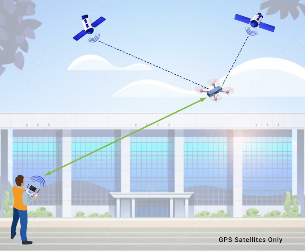
However, standard GPS alone only offers a positioning accuracy of around 2 to 10 meters. This means that using GPS by itself is insufficient for high-accuracy surveying and mapping projects.
Below: Operating a drone utilizing GPS satellite positioning.
What Does Accuracy Mean?
Accuracy in GPS refers to how closely the recorded positions match the true location in the physical world. There are two main types of accuracy that are critical to consider.
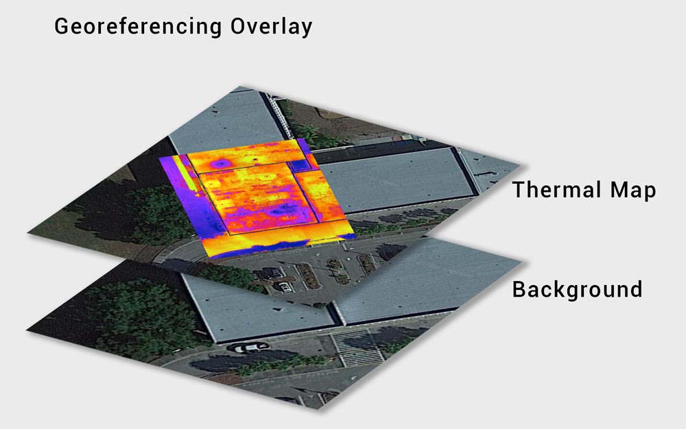
Georeferencing Accuracy: It’s crucial to ensure that spatial data aligns precisely with real-world coordinates. Georeferencing involves aligning spatial data, such as drone images, to a known coordinate system like Google Earth. When GPS coordinates used for georeferencing are inaccurate, the entire mapping or survey project can be compromised.
Below: Thermal map layer accurately positioned over the Google base map.
Relative Accuracy: Relative accuracy, which measures the consistency of GPS measurements over time, is especially important for tasks requiring precise measurements over large areas or multiple flights. Inaccuracies in relative accuracy can lead to significant errors in the final data.
What Causes GPS Errors?
To understand why standard GPS can be inaccurate, it’s important to know the factors that affect GPS satellite signals:
- Atmospheric Conditions: Variations in the atmosphere, such as ionospheric and tropospheric delays, can distort GPS signals.
- Satellite Signal Interference: Obstacles like buildings, trees, and mountains can block or reflect GPS signals, leading to errors.
- Satellite Geometry: The positioning of satellites relative to each other and the receiver affects accuracy. Poor satellite geometry can result in less accurate positioning.
- Number of Visible Satellites: More satellites in view generally lead to better accuracy, while fewer satellites can reduce it.
- Satellite Positioning Errors: Errors in the reported positions of the satellites themselves can propagate to the GPS receiver.
- Signal Reflectance: Reflected signals, also known as multipath effects, can cause inaccuracies.
- Signal Strength: Weak signals can lead to less reliable positioning data.
- Satellite Clock Errors: Inaccuracies in the satellite’s clock can affect the timing calculations used to determine position.
Fixing GPS Position Errors
Fortunately, there are several methods to improve the accuracy and obtain the quality GPS data we need:
- Ground Control Point (GCP): Known Earth surface locations used for georeferencing and mapping.
- Post-Processed Kinematic (PPK): Corrects GPS data after survey completion, useful in environments with signal interruptions.
- Real-Time Kinematic (RTK): Enhances positioning accuracy in real-time using a base station for triangulating GPS signals and providing corrections to the drone.
Having introduced the three primary methods of GPS correction, we now turn our focus to RTK. Because RTK provides real-time corrections during image capture in drone flights, it is particularly advantageous for applications demanding high precision and efficiency. Let’s delve into the specifics of how RTK works and the benefits it offers for drone operations.
How Does RTK Work?
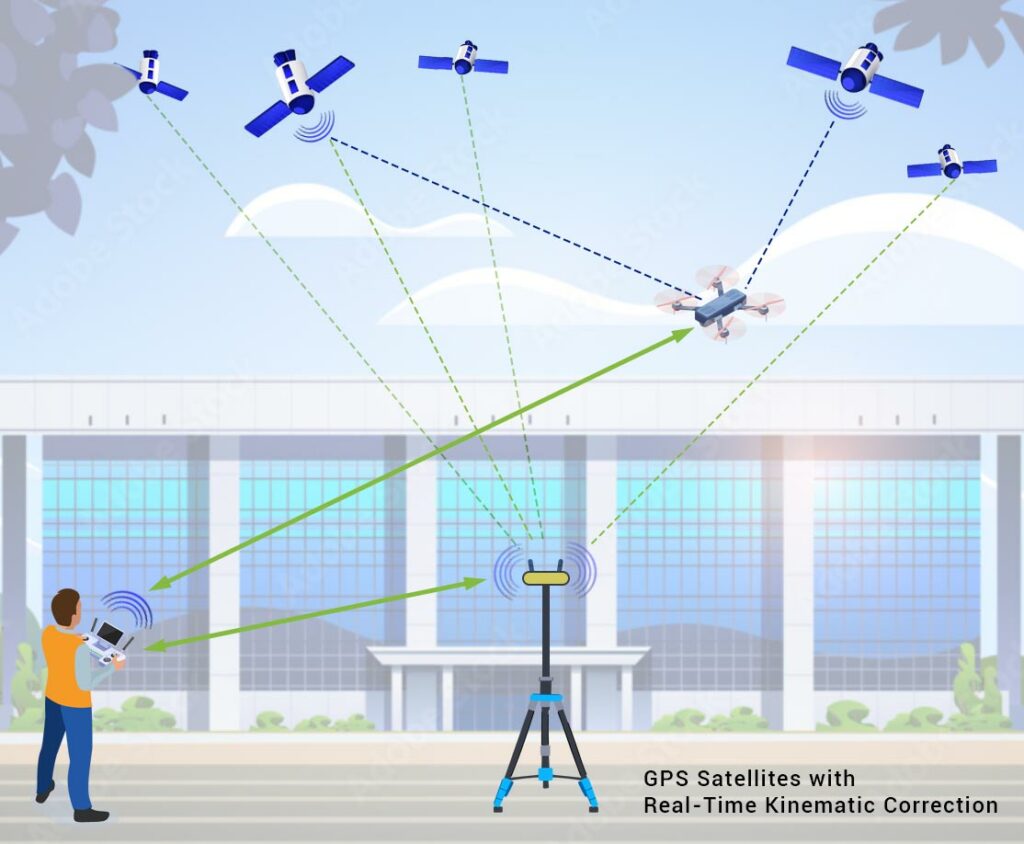
Real-Time Kinematic (RTK) is a widely used GPS correction technology that significantly improves the accuracy of positioning data by providing real-time corrections during a drone flight. The process begins with a stationary base station set up at a known, fixed location. This base station continuously receives signals from multiple satellites and the drone controller calculating the drone’s precise position through a process called triangulation.
Here’s how RTK works step-by-step:
- Base Station Setup: The base station, with a known and fixed position, receives GPS signals from multiple satellites and also from the drone via the drone controller. Using triangulation, it accurately determines any deviations in the satellite data.
- Real-Time Corrections: The base station then transmits these corrections to the drone in real-time. The drone, equipped with an RTK receiver, uses these corrections to adjust the GPS metadata in each image file.
- Enhanced Accuracy: By applying these real-time corrections, the drone’s positioning data becomes highly accurate, often achieving precision to just several inches and even down to a few centimeters.
Below: Operating a drone utilizing RTK & GPS satellite positioning.
This real-time adjustment capability of RTK eliminates most of the errors present in raw GPS data, making it especially beneficial for applications that require high precision, such as surveying, mapping, agriculture, and construction. By leveraging triangulation and real-time data transmission, RTK ensures that drone operations are both efficient and exceptionally accurate.